Hi, I'm Bharath Reddy K.
A
An ambitious, self-motivated and passionate Remote Sensing Data Engineer with a curious mind who enjoys solving complex and challenging real-world problems using Remote Sensing and Geo-spatial technologies.
About
Passionate and results-driven Data Scientist with proven expertise in machine learning, statistical analysis, remote sensing, image processing, and geospatial data science. Adept at building scalable solutions for real-world problems in water resources and environmental monitoring.
Experience
- Built reliable drought monitoring models used by government agencies.
- Designed ETL pipelines with open-source tools.
- Implemented advanced image processing workflows.
- Automated satellite data processing at scale.
- Streamlined data workflows and operational tasks.
- Leveraged multi-source geospatial data for insights.
- Developed ML models integrating satellite and field data.
- Applied data fusion for robust, reliable analytics.
- As a project trainee, I worked towards the application of object-based classification techniques for the identification of citrus orchards using Remote Sensing and GIS tools. Published and presented the same in a conference
Projects
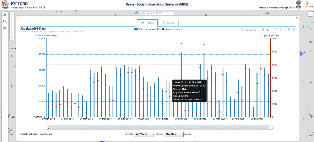
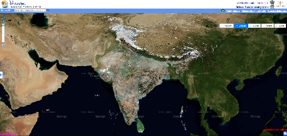
Multi satellite and sensor based water bodies surface water spread information system for India.
- Tools: GDAL, PostgreSQL, PostGIS, Python
- Developed and integrated algorithms for extraction of water spread area derived from new satellite sensors and built a robust Geospatial database of inland waterbodies.
- Advanced image processing techniques such as machinelearning, object-based techniques, etc., are employed to extract water spread area in near real-time from Optical and Synthetic Aperture Radar data derived from Copernicus missions such as Sentinel-1,2 & Indian satellites such as Resourcesat-1, 2, 2A, RISAT-1 etc.
- This database is currently being used for water assessment, inland fisheries potential, hydrological drought, etc. and is made available to the public

Hydrological Drought Assessment is a National Project with the objectives to characterize spatiotemporal variability of hydrological drought, provide hydrological drought indices based on geospatial data, hydrological model outputs and observational/field data.
A 2.5m resolution seamless ortho rectified image tiles generation using Indian Remote Sensing satellites data.

A comprehensive geo-database of water related data for Telangana State in India.

Capacity estimation of minor irrigation tanks using UAV and satellite based remote sensing.
- A novel approach was proposed and published to use images acquired from the Unmanned Aerial Vehicle (UAV) platform instead of stereo images from other sources/platforms for generating Elevation Area Capacity (EAC) relationship curves
- These EAC curves in combination with the near real-time water spread area obtained from satellite remote sensing were used to estimate the volume of water available in a tank

Orthorectified data geometric accuracy evaluator developed for quick QC.
- Fourier phase correlation with Log - Polar Transform along with Template matching using normalized cross-correlation is used in the process

Check details for other short term projects.
- Developed a classification algorithm using machine learning methods such as Quadratic Discriminant Analysis for the extraction of paddy grown regions from the Synthetic Aperture Radar data.
- Developed optimal image pair (Pan chromatic-Pan & Multispectral-MS) identification tool from a lot of Pan and MS imagery which has criteria of minimizing the number of gaps that are likely to occur in the final pan-sharpened images.
Skills
Languages and Databases
 PostgreSQL
 PostGIS
 C
C
 Matlab
Libraries
 scipy
scipy
 numba
numba
 GDAL & OGR
Geospatial Softwares
 QGIS
QGIS
 ArcGIS
 ERDAS
ERDAS
 PCI Geomatica
 Ecognition
 Orfeo Toolbox
Other
 Latex & Beamer
Education
Birla Institute of Technology And Science, Pilani (BITS Pilani)
Hyderabad, India
Degree: Master of Technology in Data Science & Engineering
- Machine Learning
- Natural Language Processing
- Deep Learning
- Big Data Systems
Relevant Courseworks:
Indian Institute of Space Science and Technology
Trivandrum, Kerala, India
Degree: Bachelor of Technology in Physical Sciences
- Remote Sensing
- Geographic Information Systems
- Digital Image Processing
- Atmospheric Sciences
Relevant Courseworks:
Publications
Achievements
Awarded scholarship for 8 consecutive semesters by Department of Space, Government of India. 120 out of 150,000 meritorious applicants received this grant.
Telangana Water Resources Information System (TWRIS), a project in was I was involved directly as a GIS data analyst was awarded with 2nd Prize under the category “Comprehensive Water Data Base in Public Domain”.
Rated as Brilliant (Grade: 10/10) for my contributions to the organization for the years 2024, 22, 21 & 20
Rated as Outstanding (Grade: 9/10) for my contributions to the organization for the year 2023, 19, 18, 17 & 16